September 2026
| Mo | Tu | We | Th | Fr | Sa | Su |
|---|---|---|---|---|---|---|
Redraws this page for that day — no reload.
The Rigolets, U.S. Highway 90 Tide Chart
Tide predictions, solunar fishing times and marine weather for The Rigolets, U.S. Highway 90, United States — updated daily, free forever.
The water level is rising.
At a glance
Pick a date
Tides
| Time | Height | Trend |
|---|---|---|
| 12:00 AM | -1.7 ft | Rising |
| 1:00 AM | -1.6 ft | Rising |
| 2:00 AM | -1.3 ft | Rising |
| 3:00 AM | -1.0 ft | Rising |
| 4:00 AM | -0.6 ft | Rising |
| 5:00 AM | -0.3 ft | Rising |
| 6:00 AM | 0.0 ft | Rising |
| 7:00 AM | 0.3 ft | Rising |
| 8:00 AM | 0.5 ft | Rising |
| 9:00 AM | 0.7 ft | Rising |
| 10:00 AM | 0.8 ft | Rising |
| 11:00 AM | 0.9 ft | Rising |
| 12:00 PM | 1.1 ft | Rising |
| 1:00 PM | 1.2 ft | Rising |
| 2:00 PM | 1.3 ft | Rising |
| 3:00 PM | 1.2 ft | Falling |
| 4:00 PM | 1.1 ft | Falling |
| 5:00 PM | 0.9 ft | Falling |
| 6:00 PM | 0.5 ft | Falling |
| 7:00 PM | 0.1 ft | Falling |
| 8:00 PM | -0.4 ft | Falling |
| 9:00 PM | -0.9 ft | Falling |
| 10:00 PM | -1.3 ft | Falling |
| 11:00 PM | -1.6 ft | Falling |
H 2:30 PM 1.3 ft
Gauge station · FES2022 global tide model · heights referenced to Mean Sea Level · America/Chicago (UTC−5) · Why might this differ?
- HAT
- 1.3 ft highest astronomical tide
- MSL
- 1.3 ft mean sea level — the chart's zero
- LAT
- 1.3 ft lowest astronomical tide
The sun rises at 06:37 and sets at 19:18. Today brings 1 high tide and 0 low tides: high water at 14:30 (0.4 m). The sun crosses the local meridian at 12:58, its highest point of the day.
Hour by hour
Interpolated heights · Thursday 3 SeptemberSea & weather now
Conditions at The Rigolets, U.S. Highway 90 right now, in station-local time.
Next 24 hours
temperature · wind · rain · humidityRain chance and millimetres per hour, then relative humidity. Scroll for the rest of the day.
UV index
solar protectionUV 7
High
High exposure — protection is essential: hat, sunglasses and SPF 30+, and take shade around midday.
- 1–2 · Low
- Little risk — most people need no sun protection.
- 3–7 · Moderate to high
- Wear a hat, sunglasses and SPF 30+, and take shade around midday.
- 8+ · Very high to extreme
- Use SPF 50+, cover up and stay out of the sun through the middle of the day.
The sea surface holds around 31.6° today, moving between 31.4° and 31.8°. Water temperature sets the pace of fish metabolism, so even a small shift can change where fish hold and how actively they feed.
Outlook
Next 7 days- Thu 3 Clear sky 94°/75° 7 mph
- Fri 4 Drizzle 89°/75° 7 mph
- Sat 5 Clear sky 92°/76° 9 mph
- Sun 6 Clear sky 94°/76° 10 mph
- Mon 7 Clear sky 98°/74° 8 mph
- Tue 8 Clear sky 96°/74° 8 mph
- Wed 9 Overcast 94°/76° 9 mph
Air quality
Moderate · EAQI 47Air quality is moderate. Sensitive groups should consider reducing prolonged outdoor exertion.
Bands follow the European Air Quality Index; the day's index is its worst hour, each pollutant its daily mean. Air quality from CAMS.
Weather & marine data by Open-Meteo.com (CC BY 4.0) · times are The Rigolets, U.S. Highway 90 local time.
Tidal coefficient · September
Bigger coefficients mean larger tides and stronger currentsMorning 47 · afternoon 39
Month range 20 – 104
Heights this month span -2.0 ft to 2.3 ft above the chart datum
Biggest tides: 9–12 Sep (coef 104) · Quietest stretch: 18–19 Sep (coef 20)
September 2026 — hover, tap or arrow-key a bar to read that day
A larger coefficient means a wider gap between high and low water, so the strongest currents run along the sea bed. Tidal range also shifts with the weather — check the wind and swell before you head out.
Swell
From ESE (102°) · 2.2 s period| Hour | Height | Period |
|---|---|---|
| 12:00 AM | 0.1 ft | 3 s |
| 1:00 AM | 0.1 ft | 3 s |
| 2:00 AM | 0.1 ft | 3 s |
| 3:00 AM | 0.1 ft | 3 s |
| 4:00 AM | 0.1 ft | 3 s |
| 5:00 AM | 0.1 ft | 3 s |
| 6:00 AM | 0.1 ft | 3 s |
| 7:00 AM | 0.1 ft | 3 s |
| 8:00 AM | 0.1 ft | 2 s |
| 9:00 AM | 0.1 ft | 2 s |
| 10:00 AM | 0.1 ft | 2 s |
| 11:00 AM | 0.1 ft | 2 s |
| 12:00 PM | 0.1 ft | 2 s |
| 1:00 PM | 0.1 ft | 2 s |
| 2:00 PM | 0.1 ft | 2 s |
| 3:00 PM | 0.1 ft | 2 s |
| 4:00 PM | 0.1 ft | 2 s |
| 5:00 PM | 0.1 ft | 2 s |
| 6:00 PM | 0.1 ft | 2 s |
| 7:00 PM | 0.1 ft | 2 s |
| 8:00 PM | 0.1 ft | 2 s |
| 9:00 PM | 0.1 ft | 2 s |
| 10:00 PM | 0.1 ft | 2 s |
| 11:00 PM | 0.1 ft | 2 s |
| 12:00 AM | 0.1 ft | 3 s |
These figures describe the swell out in open water. Closer to the beach the waves shift with the shape of the coastline and the seabed, though in most spots they end up broadly similar.
Solunar
Feeding windows from the moon's transit, rise and set — the free solunar rating for The Rigolets, U.S. Highway 90.
Best fishing times today
Solunar theory rates today a slow day for fishing at The Rigolets, U.S. Highway 90 — plan around the major and minor periods below.
4:52 AM – 6:52 AM
Moon overhead (lunar transit)
Overlaps sunrise or sunset12:43 PM – 1:43 PM
Moonset
5:22 PM – 7:22 PM
Moon underfoot (opposing transit)
Overlaps sunrise or sunset10:58 PM – 11:58 PM
Moonrise
Major periods track the moon's transit and opposing transit and run about two hours; minor periods open at moonrise and moonset and last about an hour. When a period lands on sunrise or sunset, activity climbs higher still — and that overlap happens today.
Moon
Thursday 3 SeptemberPlanner
When to go this week, and which days of September are worth the drive.
Bite windows
Thursday 3 SeptemberFish feed hardest when the water starts moving — plan around the hour before and after each tide turn.
13:30 – 15:30
Water peaks at 14:30 then starts to fall.
Best days in September
Ranked by tidal coefficient — pick a day to load it.
Quietest stretch: 18–19 Sep (coef 20)
Astronomical observation · moon, sun and Earth
today, 3 September 2026Daylight & twilight
Station local time| Light | Morning | Evening |
|---|---|---|
| Golden hourSoft, warm light — the photographer's window | 6:22 AM – 7:08 AM | 6:47 PM – 7:33 PM |
| Blue hourDeep even blue just past the sun | 6:12 AM – 6:22 AM | 7:33 PM – 7:43 PM |
| Civil twilightBright enough to work without lights | 6:12 AM – 6:37 AM | 7:18 PM – 7:43 PM |
| Nautical twilightHorizon still visible at sea | 5:44 AM – 6:12 AM | 7:43 PM – 8:11 PM |
| Astronomical twilightThe last trace of sunlight | 5:14 AM – 5:44 AM | 8:11 PM – 8:40 PM |
Lighting the Earth at this moment
8:41 PM UTC−5 · 3 September 2026 · equirectangular, 180°W → 180°E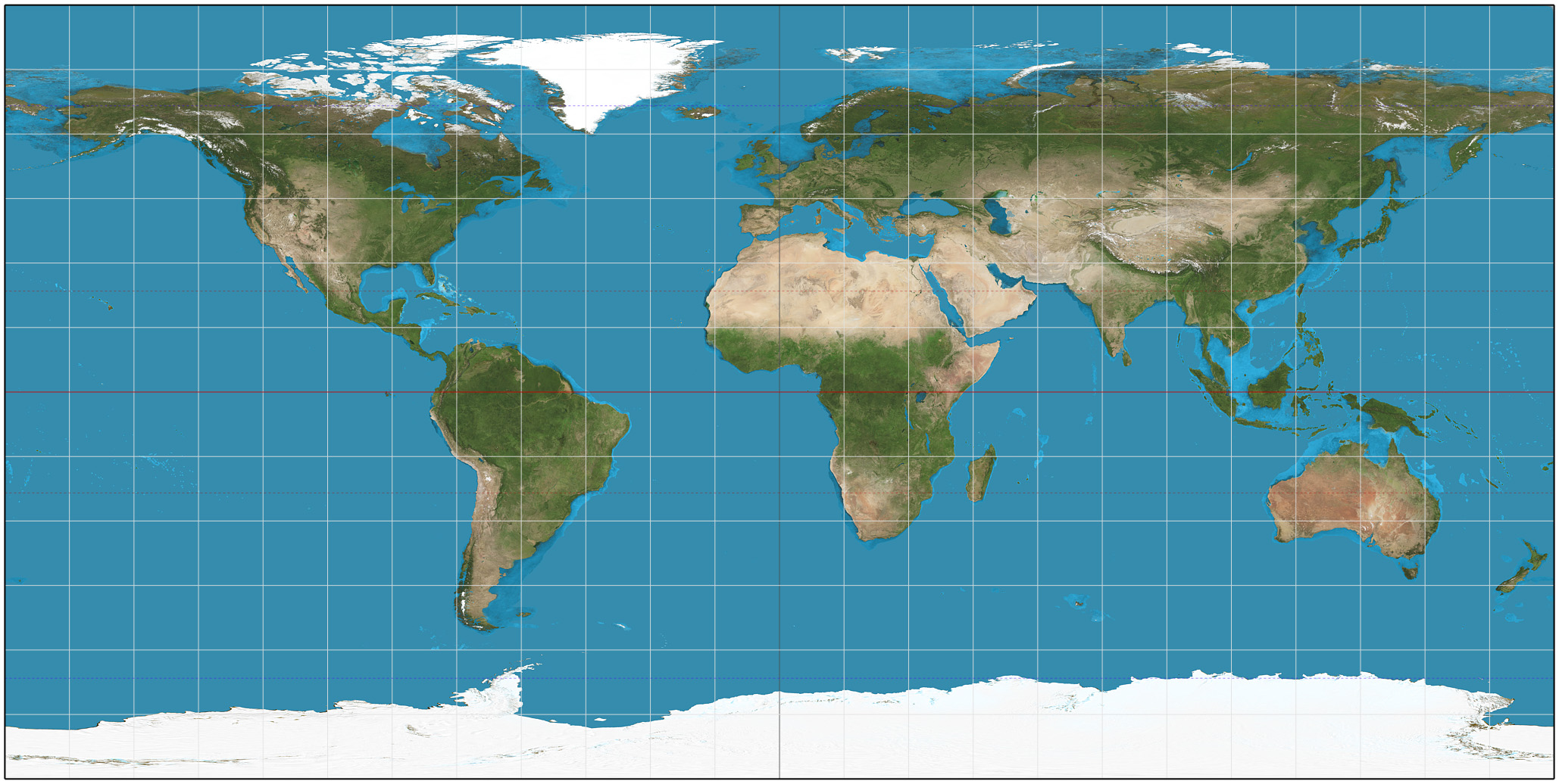
The bright band marks where the Sun stands overhead right now; the pin is The Rigolets, U.S. Highway 90. As the Earth turns, the day-and-night line sweeps westward and this map refreshes with the local clock.
Tide table
| Day | Moon | Sun | 1st tide | 2nd tide | 3rd tide | 4th tide | Coefficient | Activity |
|---|---|---|---|---|---|---|---|---|
| 1 Tue | 78% illuminated · waning | Sunrise6:35 AM Sunset7:21 PM | 2:40 PM 1.6 ft high tide | 11:40 PM -1.6 ft low tide | 70 · High | |||
| 2 Wed | 68% illuminated · waning | Sunrise6:36 AM Sunset7:20 PM | 2:40 PM 1.3 ft high tide | 11:50 PM -1.6 ft low tide | 55 · Average | |||
| 3 Thu | 57% illuminated · waning | Sunrise6:37 AM Sunset7:18 PM | 2:30 PM 1.3 ft high tide | 39 · Low | ||||
| 4 Fri | 46% illuminated · waning | Sunrise6:37 AM Sunset7:17 PM | 12:20 AM -1.6 ft low tide | 1:30 PM 1.3 ft high tide | 35 · Low | |||
| 5 Sat | 34% illuminated · waning | Sunrise6:38 AM Sunset7:16 PM | 12:50 AM -2.0 ft low tide | 12:20 PM 1.6 ft high tide | 49 · Low | |||
| 6 Sun | 24% illuminated · waning | Sunrise6:38 AM Sunset7:15 PM | 1:20 AM -2.0 ft low tide | 12:30 PM 1.6 ft high tide | 64 · Average | |||
| 7 Mon | 15% illuminated · waning | Sunrise6:39 AM Sunset7:14 PM | 1:50 AM -2.0 ft low tide | 12:50 PM 2.0 ft high tide | 79 · High | |||
| 8 Tue | 8% illuminated · waning | Sunrise6:39 AM Sunset7:12 PM | 2:20 AM -2.0 ft low tide | 1:10 PM 2.3 ft high tide | 92 · Very high | |||
| 9 Wed | 3% illuminated · waning | Sunrise6:40 AM Sunset7:11 PM | 2:20 AM -1.6 ft low tide | 1:30 PM 2.3 ft high tide | 100 · Very high | |||
| 10 Thu | 0% illuminated · waning | Sunrise6:40 AM Sunset7:10 PM | 1:40 AM -1.6 ft low tide | 1:40 PM 2.3 ft high tide | 104 · Very high | |||
| 11 Fri | 0% illuminated · waxing | Sunrise6:41 AM Sunset7:09 PM | 12:40 AM -1.6 ft low tide | 1:50 PM 2.3 ft high tide | 102 · Very high | |||
| 12 Sat | 3% illuminated · waxing | Sunrise6:41 AM Sunset7:07 PM | 12:00 AM -1.6 ft low tide | 1:50 PM 2.3 ft high tide | 11:50 PM -1.6 ft low tide | 96 · Very high | ||
| 13 Sun | 8% illuminated · waxing | Sunrise6:42 AM Sunset7:06 PM | 2:00 PM 2.0 ft high tide | 11:40 PM -1.6 ft low tide | 85 · High | |||
| 14 Mon | 14% illuminated · waxing | Sunrise6:42 AM Sunset7:05 PM | 2:00 PM 1.6 ft high tide | 11:40 PM -1.6 ft low tide | 72 · High | |||
| 15 Tue | 22% illuminated · waxing | Sunrise6:43 AM Sunset7:04 PM | 2:00 PM 1.6 ft high tide | 11:50 PM -1.6 ft low tide | 58 · Average | |||
| 16 Wed | 30% illuminated · waxing | Sunrise6:44 AM Sunset7:02 PM | 1:50 PM 1.3 ft high tide | 43 · Low | ||||
| 17 Thu | 39% illuminated · waxing | Sunrise6:44 AM Sunset7:01 PM | 12:00 AM -1.6 ft low tide | 12:50 PM 1.0 ft high tide | 29 · Low | |||
| 18 Fri | 49% illuminated · waxing | Sunrise6:45 AM Sunset7:00 PM | 12:20 AM -1.6 ft low tide | 11:30 AM 1.3 ft high tide | 20 · Low | |||
| 19 Sat | 58% illuminated · waxing | Sunrise6:45 AM Sunset6:59 PM | 12:40 AM -1.6 ft low tide | 11:20 AM 1.3 ft high tide | 25 · Low | |||
| 20 Sun | 67% illuminated · waxing | Sunrise6:46 AM Sunset6:57 PM | 12:50 AM -1.6 ft low tide | 11:30 AM 1.6 ft high tide | 39 · Low | |||
| 21 Mon | 76% illuminated · waxing | Sunrise6:46 AM Sunset6:56 PM | 1:10 AM -1.6 ft low tide | 11:50 AM 2.0 ft high tide | 53 · Average | |||
| 22 Tue | 84% illuminated · waxing | Sunrise6:47 AM Sunset6:55 PM | 1:10 AM -1.6 ft low tide | 12:10 PM 2.3 ft high tide | 67 · Average | |||
| 23 Wed | 90% illuminated · waxing | Sunrise6:47 AM Sunset6:54 PM | 12:50 AM -2.0 ft low tide | 12:30 PM 2.3 ft high tide | 80 · High | |||
| 24 Thu | 96% illuminated · waxing | Sunrise6:48 AM Sunset6:52 PM | 12:30 AM -2.0 ft low tide | 12:40 PM 2.3 ft high tide | 91 · Very high | |||
| 25 Fri | 99% illuminated · waxing | Sunrise6:49 AM Sunset6:51 PM | 12:20 AM -1.6 ft low tide | 12:50 PM 2.3 ft high tide | 11:40 PM -1.6 ft low tide | 99 · Very high | ||
| 26 Sat | 100% illuminated · waning | Sunrise6:49 AM Sunset6:50 PM | 12:50 PM 2.3 ft high tide | 10:40 PM -1.3 ft low tide | 102 · Very high | |||
| 27 Sun | 99% illuminated · waning | Sunrise6:50 AM Sunset6:49 PM | 1:00 PM 2.0 ft high tide | 10:00 PM -1.3 ft low tide | 101 · Very high | |||
| 28 Mon | 95% illuminated · waning | Sunrise6:50 AM Sunset6:47 PM | 1:00 PM 1.6 ft high tide | 9:40 PM -1.6 ft low tide | 94 · Very high | |||
| 29 Tue | 89% illuminated · waning | Sunrise6:51 AM Sunset6:46 PM | 1:10 PM 1.6 ft high tide | 9:50 PM -1.6 ft low tide | 84 · High | |||
| 30 Wed | 81% illuminated · waning | Sunrise6:51 AM Sunset6:45 PM | 1:10 PM 1.3 ft high tide | 10:10 PM -1.6 ft low tide | 70 · High |
Biggest tides: 9–12 Sep (coef 104) · Quietest stretch: 18–19 Sep (coef 20) · Morning 47 · afternoon 39. Predicted levels run between -2.0 ft and 2.3 ft this month.
Heights are metres above the station's chart datum, so the biggest tides can dip just below zero. Every time shown is The Rigolets, U.S. Highway 90 local time, with daylight saving already applied.
Nearby
Other tide stations close to The Rigolets, U.S. Highway 90, ranked by distance.
- Eden Isle 9 km
- North Shore 10 km
- The Rigolets 11 km
- Chef Menteur, Chef Menteur Pass 13 km
- Bayou BonFouca, Route 433 13 km
- North Side 13 km
- Pearlington, Pearl River Mississippi · United States 14 km
- South Point 14 km
- Michoud 24 km
- Michoud Substation, ICWW 26 km
Fishing sites near The Rigolets, U.S. Highway 90
this station in gold · nearby stations in greenMap data © OpenStreetMap contributors.
Mandeville Eden Isle Grand Isle Barataria Pass Bastian Island Bay Gardene Bay Pomme D'or Bayou BonFouca, Route 433 Bayou Chene Bayou Faleau Bayou Fearman, Vermillion Bay Bayou Rigaud, Grand Isle Breton Islands Caillou Boca Calcasieu Pass Calcasieu Ship Channel, Bulk Terminal Caminada Pass (bridge) Catfish Point, Mermentau River Chef Menteur, Chef Menteur Pass Cocodrie, Terrebonne Bay Cote Blanche Island, West Cote Blanche Bay Cypremort Point Devon Energy Facility E. ISLE DERNIERES, LAKE PELTO East Bank 1, Norco, B. LaBranche East Calcasieu Lake EAST POINT, GRAND ISLE East Timbalier Island, Timbalier Bay Empire Jetty Eugene Island
Frequently asked questions
Tides, coefficients and fishing times for The Rigolets, U.S. Highway 90, explained.
What time is high tide in The Rigolets, U.S. Highway 90 today?
High water at The Rigolets, U.S. Highway 90 today is at 14:30. The full list of high and low tide times is in the table above and refreshes every day.
Is today a good day to fish in The Rigolets, U.S. Highway 90?
Based on solunar theory the fishing rating today is Slow. The strongest windows are the major periods around the lunar transit, which often line up with sunrise and sunset.
What is the tidal coefficient and why does it matter?
The coefficient runs from 0 to 120 and measures the tidal range — today it is 39 (Low). Higher numbers mean stronger currents and a bigger gap between high and low water, which matters for fishing, diving and boating.
When are sunrise and sunset in The Rigolets, U.S. Highway 90 today?
The sun rises at 06:37 and sets at 19:18 local time, giving 12h 42m of daylight.
What is the water temperature in The Rigolets, U.S. Highway 90 today?
The sea surface at The Rigolets, U.S. Highway 90 is around 31.8°C right now. Water temperature sets the pace of fish metabolism, so the hourly strip above is worth a glance — even a small shift can change where fish hold and how actively they feed.
How big are the waves in The Rigolets, U.S. Highway 90 today?
The significant wave height at The Rigolets, U.S. Highway 90 is currently 0.0 m with a period of 2.2 s between crests. Individual sets can stack up to roughly twice that height, so allow a margin at exposed marks and anchorages.